

One focus of our research is the development of new seismic methods to image the subsurface including methods for integrated interpretation. Currently, we are working on the following topics (among others): Markov chain Monte Carlo inversion, Pn tomography and H/V analysis of submarine data.
Markov Chain Monte Carlo Tomography
We develop Markov chain Monte Carlo (McMC) methods for tomographic imaging and local earthquake localization. The main advantage of the methods is that they extensively sample the solution space and thus produce (velocity) models as well as estimates of the uncertainties. Compared to conventional methods, no initial models are necessary, data errors are automatically estimated, and the parametrization is automatically adjusted.
Publications: Ryberg & Haberland, 2018; Ryberg & Haberland, 2019
Pn tomography
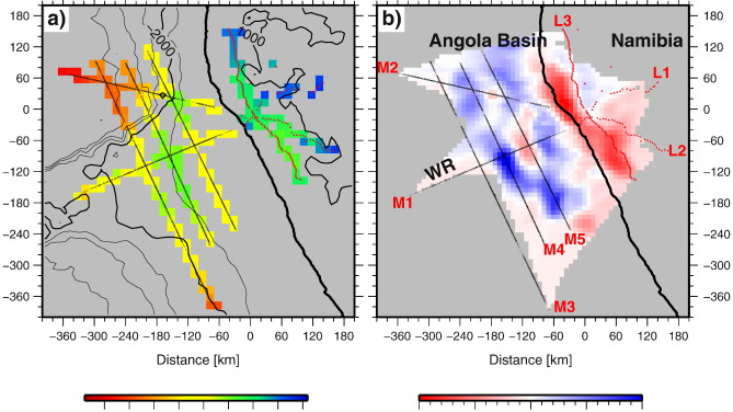
We developed a tomographic method to invert seismic Pn phases sampling Earth‘s uppermost mantle and applied the method to a controlled-source dataset from northern Namibia acquired within the DFG Priority Programme SPP SAMPLE. The analysis provide insight into the upper mantle of the landfall of the oceanic Walfish ridge, especially regarding the complex processes during continental break-up.
Projects: SPP SAMPLE
Publications: Ryberg et al., 2017; Wittig et al., 2017
H/V analysis of submarine permafrost data
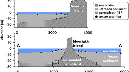
We showed that passive seismological measurements in the seafloor can be used to study the distribution and depth of the submarine permafrost layer. In particular, we use the H/V analysis of ambient seismic noise, which is well known from engineering seismology, in concert with specifically shallow water underwater seismic sensors.
Projects: MOSES
Publications: Overduin et al., 2015
Lithographic Classifications, integrated Interpretations
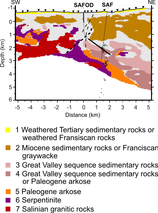
measurements primarily determine physical parameters such as seismic velocity or electrical resistance. However, estimates of the type of rock and its composition or condition are important for geological interpretation. We are working on automated methods for lithological classification, which are based on tomographic results and analysis with neural networks, among other things.
Projects: I-GET, ANCORP, DESERT,SIPOSEIS
Publications: Bauer et al., 2008, 2012a, Jousset et al., 2011, Maercklin et al., 2005, Haberland et al., 2003, Ryberg et al., 2012, Weber et al., 2012, Stankiewicz et al., 2011, Muksin et al., 2013