DFG Research Group: From Catchments as Organised Systems to Models based on Functional Units (FOR 1598)

Project G: Hydrological connectivity and its controls on hillslope and catchment scale stream flow generation (This subproject continues the work of project G within the first phase of the DFG Research Group FOR 1598 CAOS.)
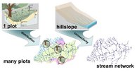
Observing and understanding connectivity within a catchment (including its spatial variability and organization as well as its temporal dynamics) is one of the central themes in advancing hydrological understanding for predicting rainfall-runoff response, solute and matter transport and in-stream variability of water quantity and quality. In this project, we focus on functional connectivity between hillslopes, riparian zones and the stream network, which is the result of how spatial patterns of structural (static) connectivity translate into fluxes and export of water, sediment and solutes. In particular, we will advance the understanding of the relevance and role of diffuse vs channelled connectivity for surface and subsurface processes and possible feedback mechanisms.
In order to observe, understand and predict these different functional connectivities from the reach scale to the meso-scale watershed, we develop and apply a range of novel observation and modelling techniques to measure functional connectivity at its appropriate scale and at the necessary repetition to draw statistically sound conclusions. In addition to the invaluable existing installations from phase 1 (subproject G) of 46 sensor cluster sites and over 20 streamflow gauging sites within a nested catchment arrangement, we have installed 60 time-lapse cameras to track the surface contributions from hillslopes to the stream network as well as the expansion and contraction of the stream network itself. Subsurface connectivity is observed at nested focus areas from the stream to a hillslope transect, based on snap-shot surveys of in-stream sampling and geophysical observation, continuous measurement in near-stream and hillslope piezometer networks and selected tracer experiments at hillslope transects. Finally, stream temperature signals, which are monitored with a dense network of temperature loggers across the Attert basin, are used as indicators of hillslope-stream connectivity and as tracers for consecutive mixing, but also serve as a unique dataset for heat balance and heat transport modelling which is deemed to be an essential counterpart to the mere modelling of water flows.
This project will make an important contribution to catchment process hydrology and modelling and hence to the CAOS research unit, as a systematic assessment of hillslope-stream connectivity is paramount to linking local scale dynamics and runoff generation to overall catchment response. This systematic assessment of connectivity, its temporal dynamics, spatial patterns and the underlying controls will thus add to our understanding of landscape organization of water flow and transport, with the potential to improve regionalization efforts considerably.
Project D: Spatio-temporal dynamics of water storage, mixing and release
The baffling diversity of streamflow generation still largely jeopardizes our efforts to anticipate how water quality and supply will be impacted under a potential future climate change. Recent work has suggested that a better understanding of how catchments collect, store and release water is the way forward in this respect. However, descriptors of water storage, flowpaths and release can be subject to considerable spatial and temporal variability. The complexity of this mixture is highly time-variant, as it is controlled by multiple factors: precipitation intensity, complexity and length of flowpaths, infiltration, soil and bedrock type, soil moisture, groundwater levels, etc. In this project we aim at answering at the following research questions: (i) How much water do catchments store?, (ii) How do catchments apportion water in space and time? and (iii) How are the hydrological functions of water collection, storage and release inter-connected? Our nested catchment set-up located in the Attert River basin provides a unique opportunity to investigate these pressing science issues with a plethora of hydrometric, geochemical and isotopic data across a large range of spatial scales and physiographic settings.
We propose to leverage the research into hydrological processes carried out in the framework of the 1st phase of the CAOS project (Project H) focusing on the 46 sensor cluster sites and the nested catchment experiments for improving our understanding of what are the dominant controls on the spatial and temporal variability of catchment functioning. Relying on a multi-tracer (geochemicals, stable isotopes of O and H, tritium) and multi-sensor (e.g. in situ and satellite-borne monitoring of soil moisture) approach, we intend to contribute to research questions on spatio-temporal variance of storage and water apportionment.
More specifically, we intend to investigate:
- the spatio-temporal dynamics of catchment storage and its compartments (i.e. saturated and unsaturated zones);
- the links between catchment characteristics, storage dynamics, temporal dynamics of transit times and end-member contributions;
- regionalization of our newly gained understanding of hydrological processes by combining hydrological mapping of dominant processes with process-based hydrological modelling.


