GCOS Reference Upper Air Network (GRUAN)

The Global Climate Observing System (GCOS) Reference Upper Air Network (GRUAN) of the World Meteorological Organization (WMO) is an international observing network, designed to meet climate requirements. Upper air observations within the GRUAN network will provide long-term high-quality climate records. The data will be used to constrain and validate data from space based remote sensors, and for scientific studies of atmospheric processes. A GNSS receiver is part of the GRUAN station equipment with highest priority (Fig. 1).
GFZ contributions to GRUAN
GRUAN GNSS Precipitable Water Task Team
The GRUAN GNSS Precipitable Water (GNSS-PW) Task Team (TT) was established in summer 2010 as one of six GRUAN TTs. These teams are charged to address critical requirements for the climatological measurements. Ground-based GNSS water vapor data was identified as priority one measurements for GRUAN. GNSS-PW TT’s goal is to develop explicit guidance on hardware, software and data management practices to obtain GNSS PW measurements of highest and consistent quality at all GRUAN sites. GFZ has been a member of this Task Team since 2011.
GRUAN GNSS Station Ny-Alesund
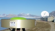
In Ny-Ålesund, a GNSS receiving system is operated by GFZ (Fig. 2) as part of the GRUAN station of Alfred Wegener Institute for Polar and Marine Research (AWI) and the French Institut Polaire Paul Emile Victor (IPEV). This Franco-German Arctic research station is the world’s first measurement station that is certified according to the standards of the GRUAN.
GRUAN GNSS Data Central Processing Centre
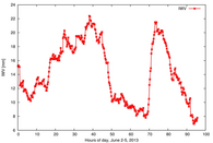
GRUAN observations are intended to provide long-term high-quality data for the reliable determination of climatological trends and to provide further insight into atmospheric processes. Precise GNSS data analysis is a key to reach data quality on the highest level. Due to its long-term experience in GNSS data processing, GFZ was selected as a Central GRUAN GNSS Data Processing Centre. An example for the GRUAN water vapour data analysis at Ny-Ålesund is shown in Fig. 3.
References
Wickert, J., K. Rannat, J. Wang, J. Braun, G. Dick, G. Elgered, S. Gutman, J. Jones, Z. Liu, and Y. Shoji, GRUAN GNSS Precipitable Water Task Team, International GNSS Workshop, Olstyn, Poland, July, 2013.
Maturilli, M., G. Dick, M. Ramatschi (2013): The GCOS Reference Upper-Air Network in Ny-Alesund, Poster, Ny-Alesund Science Managers Committee NySMAC (11th Seminar), October 9-11, 2013, National Research Council, Rome, Italy, 2013.
Ning, T., Wickert, J., Deng, Z., Heise, S., Dick, G., Vey, S., Schöne, T.:
Homogenized time series of the atmospheric water vapor content obtained from the GNSS reprocessed data. - Journal of Climate, 29, 7, p. 2443-2456, doi: 0.1175/JCLI-D-15-0158.1, 2016.
Ning, T., Wang, J., Elgered, G., Dick, G., Wickert, J., Bradke, M., Sommer, M.: The uncertainty of the atmospheric integrated water vapour estimated from GNSS observations. - Atmospheric Measurement Techniques, 9, p. 79-92, doi: 10.5194/amt-9-79-2016, 2016.


