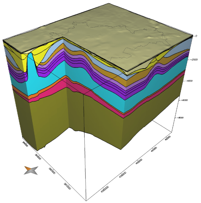
The city of Berlin is located in the Northeast German Basin. By combining previously published larger-scale 3D models of the region with new borehole-based information, we have developed a lithosphere-scale 3D model of the Berlin subsurface. This model shows a horizontal grid resolution of (500 * 500) metres and integrates a sequence of geological units that is typical for the region with fourteen Mesozoic and Cenozoic sedimentary layers, an Upper Permian (Zechstein) rock salt layer, five pre-salt crustal units, and the lithospheric mantle. It provides the geometric and physical-parametric base for two different approaches of 3D thermal simulations, (i) calculations of the steady-state purely conductive thermal field and (ii) simulations of coupled fluid flow and heat transport.
In agreement with earlier studies in the region, we find that the subsurface temperatures are strongly controlled by the thickness variations of the upper crystalline crust producing the largest amounts of radiogenic heat (per volume). Furthermore, a large contrast between high thermal conductivity of the mobilized Upper Permian Zechstein salt layer and low thermal conductivity of the Mesozoic-Cenozoic sedimentary cover causes important, yet smaller-wavelength, thermal anomalies. Where the salt shows large thicknesses as due to local diapirism, heat is efficiently transported upwards leading to lower temperatures at depth, whereas in the adjacent lows (e.g. rim synclines), the cover sediments efficiently store heat at larger depth.
Beyond this general understanding of temperature-controlling factors, the 3D thermal models yield Berlin-wide temperature variations for potential geothermal target units as the Triassic Middle Buntsandstein and the Lower Permian Sedimentary Rotliegend. Moreover, the models comprise information about the depth distributions of economically interesting isotherms (e.g. 70°C as relevant for the utilisation of heat and 110°C as relevant if electric power production is envisaged) and thus about the geological units and corresponding physical properties that are cut by these isotherms.
To lay proper foundations for later simulations of reservoirs under working conditions, we also develop physically more realistic models of coupled fluid and heat transport through the entire Berlin subsurface. The flow of groundwater, for instance, results in subsurface cooling which is strongest where the Tertiary Rupelian Clay unit, a clay-rich aquitard, is thinnest or missing thus facilitating deep reaching forced convective flow. Further improvements of the thermal models require more information on in-situ conditions and physical properties (such as permeability), in particular because of significant facies-controlled variations leading to more complicated internal configurations of the sedimentary units.
Publications
Sippel, J., Fuchs, S., Cacace, M., Braatz, A., Kastner, O., Huenges, E., & Scheck-Wenderoth, M. (2013). Deep 3D thermal modelling for the city of Berlin (Germany). Environmental earth sciences, 70(8), 3545-3566.
Kastner, O., Sippel, J., Scheck-Wenderoth, M., & Huenges, E. (2013). The deep geothermal potential of the Berlin area. Environmental earth sciences, 70(8), 3567-3584.
Kastner, O., Sippel, J., & Zimmermann, G. (2015). Regional-scale assessment of hydrothermal heat plant capacities fed from deep sedimentary aquifers in Berlin/Germany. Geothermics, 53, 353-367.
Frick, M., Scheck-Wenderoth, M., Sippel, J., & Cacace, M. (2015). Sensitivity of a 3D Geothermal Model of Berlin with Respect to Upper Boundary Conditions. Energy Procedia, 76, 291-300.
Partner
GASAG – Berliner Gaswerke AG, S. Bredel-Schürmann
Department of Geoinformation Science, Technical University Munich, Prof. Dr. T. H. Kolbe, R. Kaden


