Section 1.2: Global Geomonitoring and Gravity Field

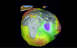
The GRACE satellites above the "Potsdam potato", a visualisation of the Earth's gravity field.

Development, Operation and Analysis of Gravity Field Satellite Missions

GFZ plays a leading role in the development, operation and analysis of modern gravity field satellite missions such as CHAMP (CHAllenging Minisatellite Payload, 2000-2010), GOCE (Gravity field and steady-state Ocean Circulation Explorer, seit 2009), the twin satellites of GRACE (Gravity Recovery and Climate Mission, seit 2002) or its successors GRACE-FO (Follow-on, launched in 2018).

Terrestrial and Airborne Gravimetry

Terrestrial gravimetry has a long tradition on the Telegraphenberg hill in Potsdam, where the former Geodetic Institute started to carry out pendulum and gravimeter measurements more than 100 years ago. Today in our Section 1.2 at GFZ we apply two modern gravimetric techniques: Superconducting and Airborne Gravimetry.

Earth System Parameters and Orbit Dynamics

Typical Earth system parameters are parameters which describe the Earth's geometrical and physical shape (ground station coordinates or gravity field spherical harmonic coefficients) and its orientation in space (Earth orientation parameters (EOP)). We estimate these Earth system parameters based on observations of satellite orbit dynamics.

Geodetic Hazard Monitoring

Geodetic observations allow monitoring of slow and rapid changes in the Earth system. A major research field of Section 1.2 is variability in sea level caused by climate impact, local subsidence or rapid events like tsunamis. Using GNSS technologies on land (e.g., at tide gauges) or off-shore (e.g., on buoys) also helps us to detect changes at the Earth surface and to analyze their hazardous potential.

back to top of main content