

![[Translate to English:] Drohne](/fileadmin/_processed_/b/a/csm_20240515_155801_427bc981d1.jpg "[Translate to English:]")
![[Translate to English:] Start der Drohnen vor dem Einsteinturm](/fileadmin/_processed_/1/7/csm_P1140911_13a95af379.jpg "[Translate to English:]")
![[Translate to English:] Rede, viele Personen im Bild vor einem Steinhaus](/fileadmin/_processed_/d/3/csm_2024_05_22_Drohnenevent_Rede_Susanne_Buiter_7b30c24d5a.jpg "[Translate to English:]")
![[Translate to English:] Präsentation der Drohne vor einem Stand](/fileadmin/_processed_/a/e/csm_20240515_162246_8aebf305d8.jpg "[Translate to English:]")
![[Translate to English:] Drohne](/fileadmin/_processed_/0/0/csm_20240515_151831_e566b0731b.jpg "[Translate to English:]")
![[Translate to English:] Drohne](/fileadmin/_processed_/b/5/csm_20240515_153504_09e7988cf7.jpg "[Translate to English:]")
![[Translate to English:] Drohne mit zwei Personen im Hintergrund](/fileadmin/_processed_/b/d/csm_2024_05_Drohnenevent_FluX_Drohne_7aa60f34f8.jpg "[Translate to English:]")
![[Translate to English:] Drohne](/fileadmin/_processed_/7/e/csm_20240515_151735_d9286f5942.webp "[Translate to English:]")
![[Translate to English:] Drohne](/fileadmin/_processed_/5/7/csm_20240515_152443_3d9d5a48ae.jpg "[Translate to English:]")
![[Translate to English:] Drohne](/fileadmin/_processed_/c/3/csm_20240515_152957_061699813d.jpg "[Translate to English:]")
![[Translate to English:] kleine Drohnen auf einem Tisch](/fileadmin/_processed_/b/2/csm_Kleine_Drohnen_f9a3fa491a.jpg "[Translate to English:]")
![[Translate to English:] GFZ](/fileadmin/_processed_/a/0/csm_20240515_153233_a137171e3e.jpg "[Translate to English:]")
![[Translate to English:] Drohne](/fileadmin/_processed_/e/7/csm_20240515_154003_4465ab9f37.jpg "[Translate to English:]")
![[Translate to English:] Luftbild der Anwesenden mit Drohne geschossen](/fileadmin/_processed_/1/1/csm_2024_05_Gruppenfoto_Drohnen_Event_Marcel_Ludwig_ef2841de95.jpg "[Translate to English:]")
As part of an outdoor event, researchers from GFZ Section 1.4 "Remote Sensing and Geoinformatics", together with colleagues from other sections, demonstrated the potential of GFZ drone technology. Researchers from neighboring institutes were also invited. The aim was also to initiate further cooperation across section and institute boundaries.
Whether as copters or gliders, equipped with laser, radar or hyperspectral sensors, large or small and handy - drones provide important services for research at the GFZ: for monitoring forests, peatlands or bodies of water, for analyzing volcanoes, landscapes and natural disasters, for mapping minerals or plants and much more.
As part of the continuous improvement of its research capabilities, the GFZ has made strategic investments in new drone platforms tailored to specific research needs in recent years. The drone systems, equipped with highly specialized sensors, have been developed together with external partners specifically to answer important scientific challenges.
Greeting from Susanne Buiter, Scientific Director of the GFZ
In her welcoming address, Susanne Buiter emphasized, among other things, the many dimensions associated with the use of state-of-the-art drone technology:
"This drone event is a wonderful idea and a great opportunity to network both within the GFZ and with potential external partners and to think about new fields of application for our infrastructure.
It is also an opportunity to show that the use of drones involves much more than just the aircraft with its sensors: it requires skilled pilots who need to stay up to date not only on technological but also regulatory and legal issues. It needs a purchasing department and other administrative units - all of which are part of a drone flight operation. And above all, it needs scientists with their projects and new ideas.
It is also great to have colleagues on board who help the scientists to transfer the knowledge gained, and in the best case also to develop spin-offs, licensing models or other ways to generate revenue and promote the transfer to society and the economy.
What particularly fascinates me is the broad spectrum of sensors. When we think of 'remote sensing', the first thing that comes to mind is our eyesight. And yes, satellites and drones can "see" from above and provide us with attractive images. But our drones, like our satellites, can do so much more than the human eye with the help of sophisticated sensors: 'sense' heat, 'smell' greenhouse gases and much more."
With regard to knowledge and technology transfer, Jörn Krupa, head of Transfer & Innovation at the GFZ, emphasizes that the growing drone expertise is relevant in several respects: "At the GFZ, we are building up knowledge on how drones can be used for various applications and are passing this knowledge on to authorities, NGOs and other partners. In the commercial sector, infrastructure rental and service measurements are also part of the spectrum. At the same time, the colleagues improve drone and monitoring technologies in the hardware sector and, finally, data acquisition and evaluation are also optimized in software development. This opens up business ideas for spin-offs or collaborations with companies, for example."
Alison Beamish, head of the Helmholtz Innovation Lab FERN.Lab adds: "User-friendly processing tools and the integration of different data is becoming increasingly important here". GFZ transfer initiatives such as the FERN.Lab, which act as a bridge between research and application, facilitate the integration of new technologies into commercial and public projects so that they can be used to tackle practical problems and challenges.
Here following you will find an overview of the drones and associated sensor technologies on display and the wide range of applications.
You can find pictures in the picture gallery above.
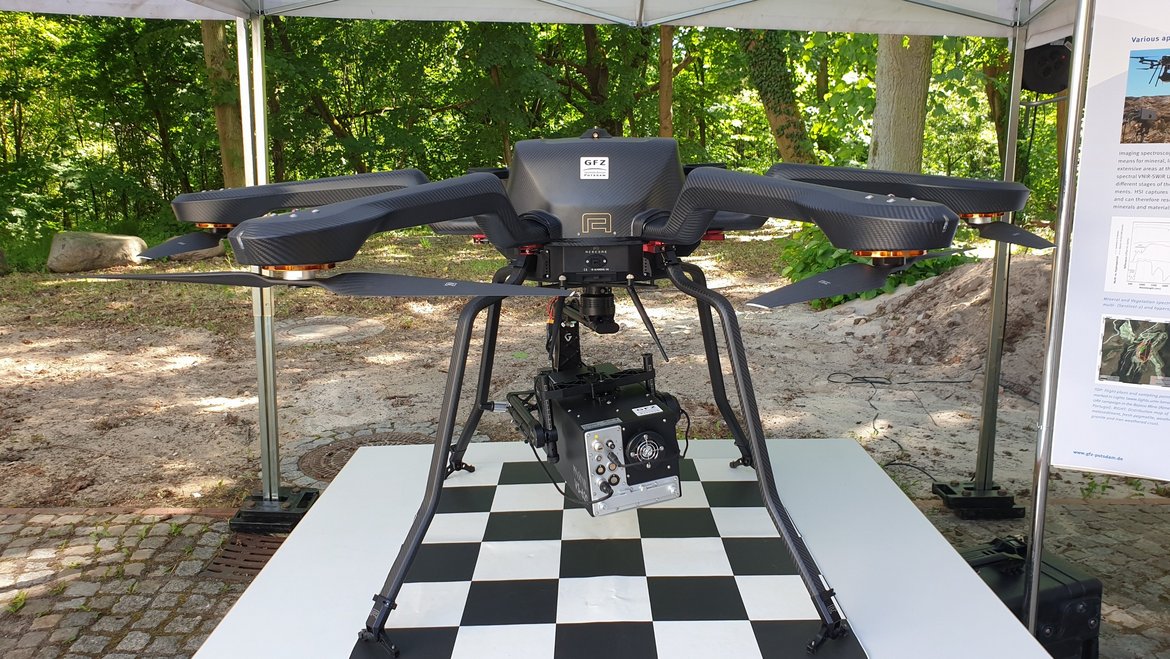
Drone copter with LIDAR | UAV VELOS V3 POR
One of the drone platforms is our LIDAR-equipped drone copter, which delivers unprecedented results, particularly when it comes to mapping terrain and analyzing landscape structure. The integration of LIDAR technology into the GFZ drone fleet enables high-resolution, three-dimensional images that are revolutionizing forest monitoring. The LIDAR drones play a central role in projects such as StrucNet/GEOTREES, a global network for the automated recording of vegetation structure and thus forest observation worldwide. The FeMoPhys project uses this technology locally. Here, a remote sensing-based observation method is being developed, whereby a physiologically based vitality assessment of the main tree species must first be carried out with the help of the drones.
Flux drones │Wingcopter 178 with Sensor-Pod I
Flux drones are another indispensable tool, especially in our efforts to monitor greenhouse gas fluxes. The maneuverability and versatility of drones allow for comprehensive data collection in difficult environments, such as over peatlands, permafrost areas or other hard-to-access ecosystems. They support the exact quantitative recording of gas flows (e.g. methane) in research projects for the rewetting of peatlands and the quantitative recording of climate-damaging outgassing from volcanoes or geological structures. The Flux drones have both a copter and a glider drive, which is important in order to avoid turbulence during gas flow measurements.
SAR drone| Explorer RD350
Our SAR (Synthetic Aperture Radar) drone, which is currently being used in Iceland, also plays an important role in monitoring volcanic activity. Monitoring is possible with SAR regardless of cloud cover and daylight and the drone allows a very high spatial resolution. Because the radar drone operates in three frequency bands (C, L and P), the surface can also be penetrated to a certain depth. This makes it possible, for example, to collect information on soil structure and moisture. The first areas of application for SAR drones were the investigation of subsidence in open-cast mining areas in western Germany and the analysis of tree root systems in Sweden.
Hyperspectral sensors are also of central importance in GFZ research, as they enable detailed spectral analyses for a range of applications. Imaging spectroscopy is a time-efficient means of mapping minerals, rocks, soils and plant species over spatially extensive areas without having to interfere with nature in any way. Our hyperspectral drone platforms complement the space-based hyperspectral system on board of the EnMAP satellite and provide, among other things, high-quality spectral data for the calibration and validation of the EnMAP system.
While some of the large drones can carry sensors weighing up to 20 kilograms, small drones offer unparalleled agility and flexibility - even when transporting them to all regions of the world. This makes them indispensable tools for our research - for example in the event of natural disasters. For example, small but very powerful thermal sensors were developed at Section 2.1 together with a Stuttgart based spin-off to provide thermal imaging data for monitoring volcanic activity.
The small, low-cost drones are also of great importance in the GFZ's transfer activities, particularly in the fields of agriculture and biodiversity monitoring. Data acquisition with drones and image analysis based on artificial intelligence play a major role in the modelling of habitats, the mapping of ecosystems, the planning of agricultural measures such as precise fertilization, but also renaturation measures or the monitoring of protected areas. The sensors can record how plants spread, grow, flower and react to changing environmental conditions such as heat and drought down to the level of individual plants.
Further information:
- Section "Remote sensing and Geoinformatics"
- UAV Pool of section 1.4
- Projekt LauMon


