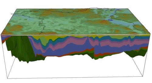
3D structural modelling of Brandenburg (NE German Basin) and evaluation of the dominant control mechanism for the present-day thermal field
Brandenburg is located in the north-east German part of the Central European Basin System, which extends from the North Sea to Poland. In this area the basin fill consists of nearly undisturbed Rotliegend clastics and a thick layer of strongly mobilised Zechstein salt (both Permian) as well as of the overburden Mesozoic and Cenozoic sediments. Accordingly, the internal structural setting of the area is morphologically differentiated by numerous salt structures. Based on different raw data we develop a 3D structural model of the basin fill, which integrates the sediment thicknesses of the stratigraphical units in a refined resolution than previous models. This 3D model is then used as a base for modelling the present-day thermal field. In addition to the sediment sequence, we also consider the configuration of the deeper crust and the lithospheric mantle. A series of sensitivity studies will help to assess the influence of spatially variable facies, structure and thermal parameters on the temperature distribution at depth to facilitate improved predictions for geothermal exploration.
Poster
Sensitivity of 3D thermal models in Brandenburg
Assessment of the impact of moving fluids on the regional thermal field for the area of Brandenburg (North German Basin)
Cooperations
Landesamt für Bergbau, Geologie und Rohstoffe Brandenburg
Landesamt für Geologie und Bergwesen Sachsen-Anhalt
Landesamt für Umwelt, Naturschutz und Geologie Mecklenburg-Vorpommern
GeoEn
Internationales Geothermiezentrum GFZ
Funding
Helmholtz Centre Potsdam GFZ German Research Centre for Geoscience
Bundesministerium für Bildung und Forschung - BMBF
Im Rahmen der "Spitzenforschung und Innovation in den neuen Ländern" GeoEnergie Verbundprojekt zwischen Universität Potsdam, BTU Cottbus und Helmholtz-Zentrum Potsdam Deutsches Geoforschungszentrum GFZ
More information about GeoEn


