Regional Flood Model for Germany
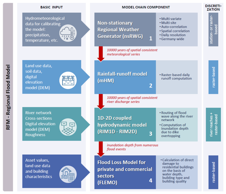
Flood risk analysis has traditionally been carried out at a local scale. There is, however, a need to identify flood prone areas and the associated risk at a national scale so that planning and resource allocation to undertake flood defence measures can be done in an effective way. Previously applied methodologies have considerable drawbacks that should be overcome. These include an assumption of the uniform flood magnitude countrywide for one scenario, application of steady state instead of dynamic hydraulic modelling approaches as well as disregarding of flood protection structures and their possible failures. The aim of this project is to develop a modelling system to produce a coherent regional flood risk assessment covering the whole of Germany. The system will consist of a chain of models covering the main processes of flood generation and damage.
Results
Germany-wide flood risk assessment
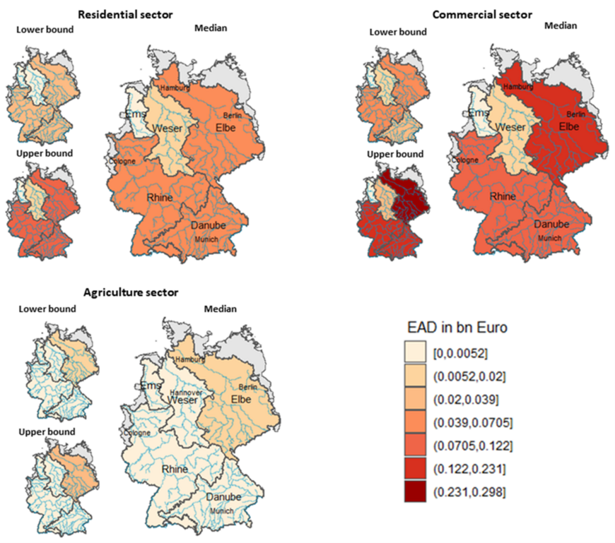
With the RFM model chain, a first uniform regional risk assessment could be carried out for the five large catchment areas in Germany (Sairam et al., 2021). In contrast to the risk assessments of the individual Federal States as part of the implementation of the EU Flood Directive, a uniform, continuous model simulation was applied across Federal State borders and the risk assessments for the three sectors of private households, commerce/industry and agriculture were carried out. The results show that the greatest risk in Germany is in the commercial sector. While the expected damage values for the private sector are similar in the three largest basins (Elbe, Rhine, Danube), the values for the commercial and agricultural sectors in the Elbe catchment area stand out.
Publication:
Sairam, N., Brill, F., Sieg, T., Farrag, M., Kellermann, P., Nguyen, V. D., Lüdtke, S., Merz, B., Schröter, K., Vorogushyn, S., & Kreibich, H. (2021). Process-based flood risk assessment for Germany. Earth's Future, 9(10), e2021EF002259. doi.org/10.1029/2021EF002259
Sensitivity of flood risk to changes in the process components and to spatial dependencies
In the study by Duha Metin et al. (2018), RFM was used to analyze the sensitivities of flood risk to changes in various parameters along the risk process chain such as precipitation, temperature, flood retention basins, dike height, exposure and vulnerability. Furthermore, the effect of the assumptions on the spatial dependencies of the return periods of flood discharges in different sub-catchments on risk assessment was investigated (Duha Metin et al., 2020). It was shown that the estimation of the expected annual damage is virtually independent of the assumption on dependency, while an error of up to 50% is possible in the estimation of the 200-year damage assuming complete dependence or independence compared to spatially consistent estimation.
Publications:
Duha Metin, A., Viet Dung, N., Schröter, K., Guse, B., Apel, H., Kreibich, H., Vorogushyn, S., & Merz, B. (2018). How do changes along the risk chain affect flood risk? Natural Hazards and Earth System Sciences, 18(11). doi.org/10.5194/nhess-18-3089-2018
Duha Metin, A., Viet Dung, N., Schröter, K., Vorogushyn, S., Guse, B., Kreibich, H., & Merz, B. (2020). The role of spatial dependence for large-scale flood risk estimation. Natural Hazards and Earth System Sciences, 20(4). https://doi.org/10.5194/nhess-20-967-2020
Spatially consistent flood risk assessment for meso-scale catchments
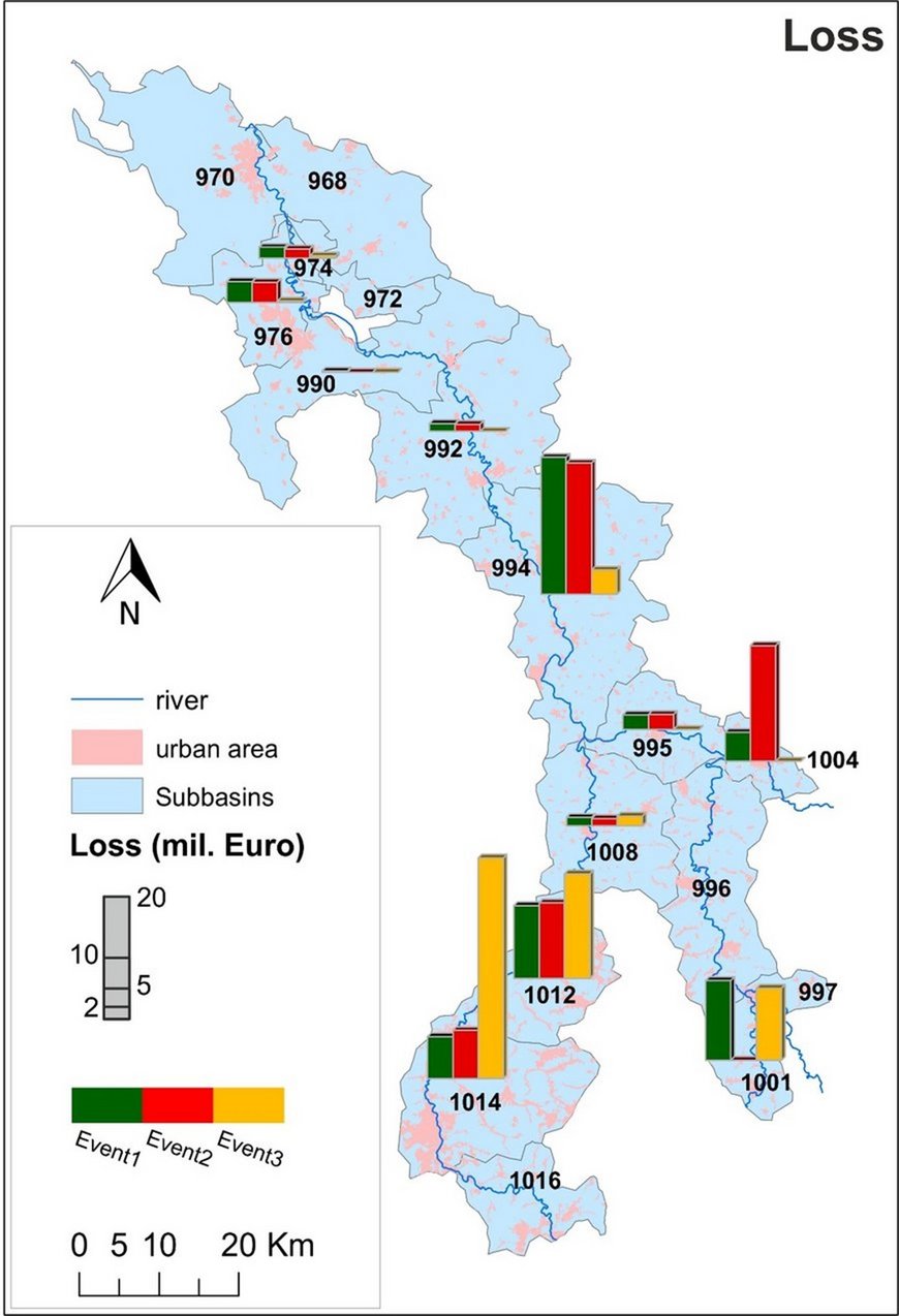
The first spatially consistent simulation of flood discharges, inundation areas and damage at the scale of large and meso-scale catchments (Elbe, Mulde) was carried out using RFM (Falter et al., 2015, 2016). For the Mulde catchment, the risk assessment is based on 10,000 years of synthetically generated climate time series, which were used to drive a hydrological model. The inundation areas for more than 2000 events in this period were calculated at 100 m spatial resolution and formed the basis for damage modeling.
Publications:
Falter, D., Dung, N. V., Vorogushyn, S., Schröter, K., Hundecha, Y., Kreibich, H., Apel, H., Theisselmann, F., & Merz, B. (2016). Continuous, large-scale simulation model for flood risk assessments: Proof-of-concept. Journal of Flood Risk Management, 9(1), 3-21. doi.org/10.1111/jfr3.12105
Falter, D., Schröter, K., Dung, N. V., Vorogushyn, S., Kreibich, H., Hundecha, Y., Apel, H., & Merz, B. (2015). Spatially coherent flood risk assessment based on long-term continuous simulation with a coupled model chain. Journal of Hydrology, 524, 182-193. doi.org/10.1016/j.jhydrol.2015.02.021


