GFZ German research centre for geo sciences

Section 1.4: Remote Sensing and Geoinformatics

Hyperspectral remote sensing applications

This topic focuses on the development of new methodologies using multi-scale and multi-sensor hyperspectral remote sensing (from the laboratory and field operations to airborne and satellite applications) for geosciences and environmental applications.

EO mission development and data processing

Our group focuses on the development of future EO sensors and state of the art data pre-processing algorithms. Our activities cover a broad spectrum of research fields such as hyperspectral sensors, sensor end-to-end simulations, night illumination, radiative transfer, atmospheric correction, big data processing, as well as geometric fusion of hyperspectral and Lidar data.

Integration of in-situ and remote sensing data (TERENO)

The research of the GFZ Section for Remote Sensing and Geoinformatics within the TERENO working group focuses on the monitoring of surface parameters, based on the synergetic use of ground-based in-situ measurements from climate and soil moisture measuring stations with remote sensing based analyses. The focus is on the long-term monitoring of mainly agricultural areas.

Radar and optical remote sensing for geohazards

Our working group deals with the development and application of remote sensing methods using radar and optical data for a comprehensive understanding of natural and anthropogenic geohazards. Our primary goal consists in obtaining an improved spatiotemporal process understanding as an important basis for improved hazard and risk assessment. Methodological developments are based on optical as well as on radar data aiming at their combined use for a best possible information extraction.

Earth-Atmosphere Interactions (TEAM)

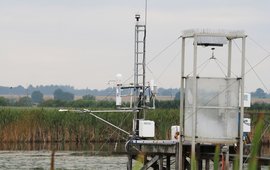
The Earth-Atmosphere Interactions Group has evolved from the Helmholtz Young Investigators Group TEAM: "Trace Gas Exchange in the Earth-Atmosphere System on Multiple Scales".

Young Investigator Group Leader: Prof. Torsten Sachs

Big Data Analytics

The working group develops concepts and software tools to analyse and interprete large, high-dimensional, heterogeneous and often uncertain data sets. It combines methods from data mining/machine learning, visual data exploration, data bases and big data technologies into novel approaches.

Bress instrument

Global Land Monitoring

The GLM group is developing and deploying novel methodological approaches to enhance the systematic, large-area monitoring for land dynamics worldwide ...

Technology transfer for remote sensing

The working group activities focus on the transfer of remote sensing knowledge, methods and software solutions outside of academia. The expertise of scientific method development is combined with sustainable software development and aspects of capacity building. The Helmholtz Innovation Lab FERN.Lab is located in the working group.

back to top of main content